Motorcycle routes & riding coach. Made for
the bends.
Find better roads. Ride them. Read every corner.
Twisty-road routing, a clean riding cockpit and corner-by-corner analysis that shows what to work on next.
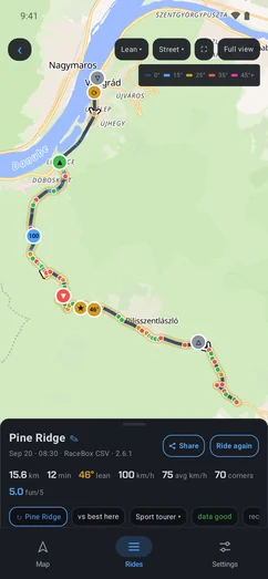
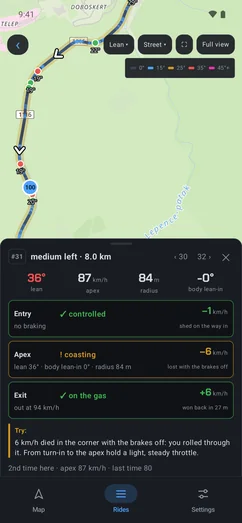
Find. Ride. Read.
One loop, from the plan to the debrief, and the next ride starts smarter than the last.
-
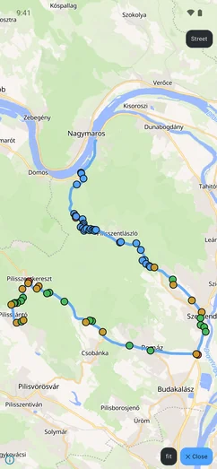
1 · Find the bends
Choose Twisty and every route is scored by its bends, not just the clock. Hairpin knows the best sections nearby and threads them into your route.
-
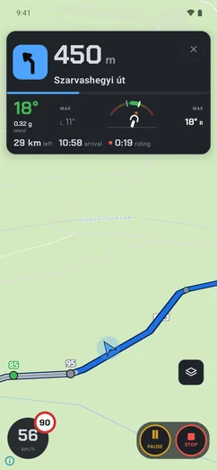
2 · Ride with a clean cockpit
Only what is useful on the road: the next turn, your lean and the speed limit, big enough to read at a glance. Hazards on your route are spoken once.
-
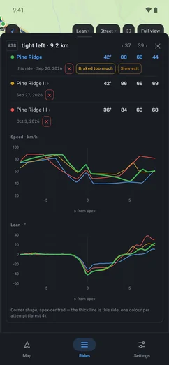
3 · Read every corner
Three verdicts per corner and one thing to try, and the few corners most worth working on. Ride them again and watch the clean ones add up.
Corner Coach
Every corner, read back.
Hairpin doesn’t just record your ride. It remembers how you ride.
- 1Entrycontrolled · rushed · late braking
- 2Apexsteady · coasting · parked
- 3Exiton the gas · late on the gas · rolled off
#12 · Tight left
12.3 km · after Pine Ridge (R17)
- lean
- 39°
- at the apex
- 50 km/h
- radius
- 24 m
- EntryControlled−18 km/h shed
- ApexSteady−2 km/h lost
- ExitLate on the gas+6 km/h gained
Try Once you can see the exit, roll the throttle on smoothly. This one opens up after the apex.
What you learn
Each corner split into entry, apex and exit, a verdict for each, and the one thing most worth trying next time.
What to work on
Focus names the phase to practise; Work on these picks the corners where it will pay off.
What it remembers
Every corner you ride again keeps its history, and your season adds up how your entries, apexes and exits are going.
Works with your phone. Pair a RaceBox and every corner also gets brake points, release lean and body lean-in. Where a sensor can’t tell, the card says so.
Hairpin Trail
When the tarmac ends.
The same loop off the road. Hairpin Trail routes by surface, draws the line by how rough it gets and keeps to tracks you’re allowed to ride.
- Three tiers
- ADV, gravel or enduro: each decides which tracks and surfaces your route may use.
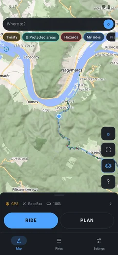
- Routed by surface
- The route is coloured by the ground under it, from tarmac to rough track.
- Legal tracks only
- Tracks in forests, national parks and protected areas are left out. Natura 2000 sites in Hungary are flagged, and can be avoided.
- Dirt roads on the map
- The best unpaved sections nearby, shown the way twisty roads are shown for tarmac.
- Your GPX trails
- Bring a multi-day trail. Hairpin joins its sections, cuts it into days that end near fuel and routes you to the start.
- Fuel range
- A warning before any stretch longer than your tank.
- Offline all the way
- Maps, routing and your trails keep working with no signal.
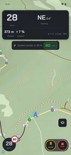
- The offroad cockpit
- Heading, altitude, live gradient and the way back to the trail.
- Rejoin the trail
- Off the line, a Rejoin button routes you back to it.
- Read the ride
- Terrain sections, roughness, climbs and jumps, after every ride.
Hairpin Trail’s offroad routing covers most of Europe: 40 countries. Where the law allows public roads only, as in Italy, Spain or Norway, it plans on public gravel roads.
Made for the bends. Ready for the dirt.
Everything in Hairpin
1Find
Roads worth the ride.
- Round trips
- A distance, a direction, no road twice.
- Known twisty roads
- The best sections nearby, in your route.
- Stops and places
- Fuel, food, cafés and viewpoints on the way.
3 more in Find
- Twisty routes
- Scored by their bends, rated 0–5.
- Offroad routes
- ADV, gravel or enduro, on legal tracks.
- Web to phone
- Plan on the web, ride on the phone; GPX too.
2Ride
Only what you need on the bars.
- Hazard alerts
- Spoken once, and only when on your route.
- Speed limits
- The road’s limit, right on your speed disc.
- Offline maps and routing
- Plan and navigate with no signal.
3 more in Ride
- A clean cockpit
- Next turn, lean and speed limit at a glance.
- Rerouting
- Miss a turn; your stops and settings stay.
- Portrait or landscape
- Mount the phone either way.
3Read
What every corner tells you.
- AI analysis
- A written debrief; ask about any corner.
- RaceBox logging
- Brake points and lean-in, 25 times a second.
- Compare
- Two rides of one road, corner by corner.
5 more in Read
- Corner analysis
- Entry, apex and exit, each with a verdict.
- Work on these
- The corners most worth practising.
- Corner memory
- How each corner went last time.
- Season view
- Entries, apexes and exits across the season.
- Share cards
- A card for every ride and every season.
Route planning works worldwide: Twisty mode picks roads by their bends, and the known twisty roads show everywhere. Across Europe, offline maps are everywhere and offroad routing covers 40 countries. Speed cameras are covered wherever they are mapped, closures and roadworks in Hungary.
Ride it today.
Hairpin is on Google Play for Android, and in your browser. Free to use; Pro is an optional subscription.
-
Android
Plan, navigate, record and read every corner.

-
Web
Plan routes and read your rides on a big screen, with the same account.
Open Hairpin on the web -
iPhone
In App Store review now. Coming soon.
Questions
Where does it work?
Route planning (Twisty mode included), the known twisty roads, navigation and ride analysis work worldwide. In Europe you also get offline maps everywhere, and Hairpin Trail’s offroad routing in 40 countries (not yet in the UK). Offline maps for the rest of the world are coming.
Do I need a RaceBox?
No. Your phone records the ride and reads the corners. Pair a RaceBox and it logs 25 times a second, adding brake points, release lean and body lean-in.
Does it work without signal?
Yes. Download the countries you ride: maps, routing and your trails run on the phone.
Is Hairpin Trail legal where I ride?
Hairpin Trail leaves out tracks in forests, national parks and protected areas, and keeps tracks that are explicitly open. In Hungary it also flags Natura 2000 sites and can avoid them. Local rules change, so the signs on the ground always win.
Can I bring my own GPX trail?
Yes. Import a multi-day trail: Hairpin joins its sections, cuts it into days that end near fuel and routes you to the start. The file stays on your phone.
Which bikes?
Any. Add yours to the garage and rides are tagged to it; nothing requires it.